Campus Development 1969-1993
The Erickson / Massey Plan, 1969
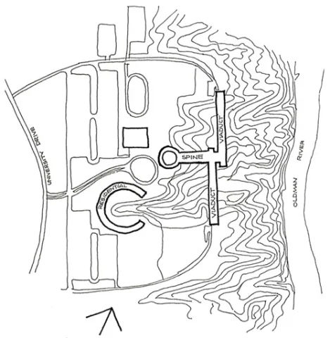
The University of Lethbridge site is located on the west bank of the Oldman River. The plateau area at its approaches from University Drive falls to the river in a distinctive landscape of undulating and denuded coulees.
The Erickson / Massey Plan of 1969 located parking areas, playing fields and ovals and associated indoor facilities in the western plateau area with central facilities (library, student union building and administration) extending from the arrival plateau down a ridge between two coulee formations to the northa dn south wings of academic facilities (arts, science, etc.) which bridged across the coulees in viaduct form at the bottom of the central facilities spine. The north wing was to accommodate Social Sciences and Humanities and the south, Physical and Life Sciences.
Student residences were formed in a crescent on the plateau at the head of one of the coulee formations and additional housing was integrated underneath the viaducts of academic facilities bridging across the lower slopes of the coulees.
University Hall, the northern 'viaduct' of academic and residential facilities, parking areas and sporting facilities are the only elements of the University which have closely followed the very formal 1969 Campus Plan.
Subsequent Development
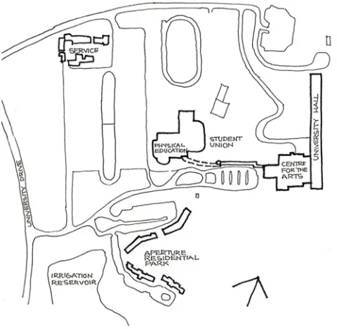
Nevertheless, the 1969 Plan has provided a framework to the subsequent development of the University while accommodating a number of departures:
- The residential complex at the head of the southern coulee has been constructed as four informally grouped buidlings with individual carparks.
- The service buildings have been located in the north-western carpark area rather than on the north side of Valley Road.
- A large irrigation reservoir has been constructed to the south-west of the residential complex in an area initially planned for carparking.
- Central and academic facilities have been staged, the 1969 concept of a spinal building complex with north and south viaduct wings being incomplete. This has resulted in the University having no main front entrance at the present time and inconsistency in common and specialist functions in both 'spine' and 'viaduct' areas. For instance, central facilities such as the Library are located in the only completed viaduct wing, University Hall, which was constructed as stage 1 of the University, as well as Social Sciences, Humanities, and Physical and Life Sciences. The subsequent spinal addition to University Hall accommodates Fine Arts in addition to central facilities such as a theatre complex around a major auditorium with stage facilities.
The facilities of the University of Lethbridge are thus not organised in a coherent central spinal and academic wing grouping. The inadequacies of the structure of completed buildings on the coulee areas of the campus also necessitate that a reassessment of constructional approach as well as location of facilities is imperative in future development of the University of Lethbridge.
Excerpt from Pages 3 - 4