Welcome to the University of Lethbridge
  • Library
  • Directory
  • Intranet
  • MyExperience
  • Webmail
  • Bridge
  • Moodle
Study here Give
U of L Campus Master Plan
Close
  • About
  • Planning History
    • Development Plan (1969)
    • Phase IV Report (1990)
    • Plan Review (1993)
    • Master Plan Report (2000)
    • Precinct Plan (2000)
    • Expansion Plan (2001)
    • Archival Gallery
  • Planning Process
    • Project Initiation
    • Planning Phases
  • UCMP (2012)
  • Contact
  • Library
  • Directory
  • Intranet
  • MyExperience
  • Webmail
  • Bridge
  • Moodle
Study here Give
Planning History
  • Development Plan (1969)
    • The Vision
    • Planning Models
    • Objectives
    • Goals
    • Site Parameters
      • Environmental Data
      • Topography and Vegative Cover
      • Soils
      • Prairie Landscape
    • Planning Objectives
    • The Development Plan
      • Land Use
      • Circulation
      • Form and Massing
      • Landscape
      • Academic Area
    • Implementation
    • Accolades
  • Phase IV Report (1990)
    • Design Goals
    • Long Range Plan
    • Analysis of Plan Options
  • Plan Review (1993)
    • Development Guidelines
    • Campus Development 1969-1993
    • Current Issues
    • Strategy for Future Development
    • Recommended Development
      • Site A - South Coulee
      • Site B - West Ridge
      • Site C - North University Hall
  • Master Plan Report (2000)
    • Modified Anderson Hall Model
    • Key Development Guidelines
    • Site Development Strategy
    • Master Plan Directions
      • Site Plan
      • Site Topography
      • Landscape Plan
      • Pedestrian Routes
      • Vehicular Routes
      • Future Projects
      • Precinct Plans
  • Precinct Plan (2000)
    • Master Plan Report (2000)
    • Precinct Plans
    • Conceptual Design Guidelines
    • Project/Master Plan Reviews
    • Life Sciences Building
  • Expansion Plan (2001)
    • Key Findings
    • Campus Vision
    • Campus Design Concepts
      • Phase 1
      • Phase 2
  • Archival Gallery

Master Plan Report (2000)

Following their review of the campus Development Plan in 1993, the University commissioned John Andrews International Pty. Limited to return to complete a new Master Plan Report to guide development of the campus into the new millenium during a particularly difficult financial climate for the University.

The planning review involved reviewing the work they completed in 1993, a site visit and a number of meetings with University representatives and architects working on current projects. The updated 2000 plan report was offered as guidance for the immediate and future development of the campus and was believed to be a 'working document' for the University.

This Master Plan Report embeds the assumption that 'future funding for building projects at the University of Lethbridge will be limited' and that a single storey building expansion solution on the flat plateau (based generically on Anderson Hall) is the 'most appropriate model' for future development. Hence, previously proposed multi-storey building expansion identified in 1969 and subsequently in 1993 were viewed as 'unlikely to proceed' in those proposed locations.

See Master Plan Report - John Andrews Architects (2000).

Image

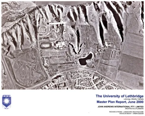
The Master Plan Report of 2000 represented a departure from a comprehensive formal approach to campus planning toward a precinct concept, whereby the campus is divided into distinct planning areas.

The report acknowledges the following departures from development plans up to 1993 (pp. 1.1):

  1. The residential complex at the head of the southern coulee constructed instead as four informally grouped buildings rather than a monolithic crescent responding to the unique coulee landforms or with a predetermination to house not only students but residents of the west city area.
  2. The (temporary) service buildings located in the far north western car park area rather than on the north side of Valley Road.
  3. A large irrigation reservoir constructed in an area originally planned for parking to the south west of the residential complex.
  4. Indirect visitor access to academic and community facilities due to the staged development of core facilities between the western car park area and University Hall.

Introduction of Precinct Areas

The development of precint areas was concieved to provide conceptual Design Guidelines for each new project as funding became available within the precinct the project was located. Much of this thought was not carried through due to the replacement of the (2000) Master Plan Report the following year by the Brook McIlroy plan of 2001.

Students

  • Academic calendar
  • Student Enrolment and Registrar Services
  • Student opportunities
  • Student services
  • Study here

Information for

  • Alumni
  • Donors
  • Visitors and community

Campus

  • Careers at uLethbridge
  • Events
  • Faculty and staff intranet
  • Maps and tours
  • News
Visit the University of Lethbridge Homepage
  • Lethbridge, Alberta, Canada
  • Contact us
  • Calgary Campus
  • Faculty and staff directory

The University is located on traditional Blackfoot Confederacy territory. We honour the Blackfoot people and their traditional ways of knowing in caring for this land, as well as all Aboriginal peoples who have helped shape and continue to strengthen our University community.

©2025 University of Lethbridge | Terms of use