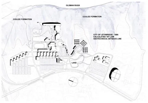
Site Topography
The main campus site occupies both plateau and coulee areas on the west bank high above the Oldman River Valley. Coulee formations occupy nearly half of the main campus property. Much of the property remains in a parkland or naturalized state. The topography varies from east to west with both steep and gradual elevation changes. This setting makes for a dramatic landscape tied to precious ecology, views and a unique historic context.

Oldman River Valley Area
Within the City of Lethbridge, the Oldman River Valley Area bisects the city covering a land area of almost 3700 hectares of coulee and river shoreline. The University main campus property occupies less than 5 per cent of this coulee and riverbank area.
The Lethbridge River Valley Development Scheme (By-law #3255), enacted in 1975, provided the necessary development control procedures to restrict development where necessary and encourage recreation and development.
The need for a River Valley Area Redevlopment Plan was identified in the 1980 General Municipal Plan. The General Municipal Plan also proposed that the City continue to support the development of the river valley as a regional recreation resource.
The 1983 an Urban Parks Master Plan outlined a long range plan for the development of recreation activities for the City of Lethbridge. A major portion of the master plan area focused on the Oldman River Valley. While the master plan was not intended to provide the land use protection and control mechanisms of an Area Redevelopment Plan, important findings of the master plan which are relevant to the area redevelopment plan included the following information:
- The severe geotechnical and flood hazard constraints to development in the river valley;
- The extent and diversity of natural and historic resources in the river valley;
- The fact that only a portion of river valley lands are identified for public park development;
- With the nodal park development proposed for the valley, the critical need for access to recreation facilities and linkages within and to the river valley; and
- The importance of situating only compatible land uses in close proximity to the river valley.
Development within the river valley has remained quite static over the past few years (early 2000). While existing private land uses remain, pressure for redevelopment has not been as evident as in other cities. The most contentious applications have related to residential development. Residential development proposals have included the Lethbridge Country Club lands and the Stasiuk property. In both situations City Council acted decisively and opposed the residential development proposals.
The most common concerns with respect to development of the toplands and coulees relate to bank stability and the need for a development setback. Natural erosion, potential subsidence from early coal mining, alterations to natural runoff and groundwater patterns, and infilling of the coulees affect bank stability.
Because of the types of soils present, fluctuations in the water table play a significant role in determining bank stability. Since the issue is complex, geotechnical studies are commonly required prior to subdivision approval. The policy of relating subdivision approval to a positive geotechnical study has been generally accepted.
The City has, in recent years, used the Alberta Land Conservation Guidelines as an initial reference for determining appropriate setbacks from the top of the bank and associated coulees in the situation where a site specific geotechnical study has not been performed.
The river valley has three environmentally distinct zones which include the top of bank area, the valley and coulee slopes, and the base of the river valley, including the flood plain. The vegetative environment varies with exposure and orientation and this in turn affects bank stability, erosion and habitat productivity for wildlife.
In July, 2004, the City of Lethbridge adopted Bylaw 5277 which utilizes the River Valley Area Development Plan (RVADP) to provide guidelines for appropriate development with the main intent to preserve this area for recreation purposes. The purpose of the RVADP is stated within the plan as follows:
The River Valley Area Redevelopment Plan is intended to provide direction to guide the development of the Oldman River Valley area within the City of Lethbridge. This Area Redevelopment Plan has a unique function in that it does not propose a set land use pattern for the redevelopment area, but rather establishes parameters within which various options may occur. Within this broad framework it is intended that the Plan will provide adequate protection for the river valley and its users. Protection of the river valley resource will be achieved through the development of land use control measures, land use by-law and development guidelines.
Ultimately, the City may approve development closer to the river valley on the condition that the developer submit, at his cost, an acceptable site-specific geotechnical analysis which demonstrates that the setback requirements outlined in Sections 3.3, 3.4 and 3.5 of the RVADP are not applicable to that particular piece of land.
The goals of the RVADP are as follows:
Public Protection
- To protect the public from natural hazards associated with development in or adjacent to the river valley.
Resource Protection and Enhancement
- To protect and enhance the significant and unique natural development in or adjacent to the river valley.
Land Use Management
- To accommodate the use of the river valley for purposes compatible with the physical and biological characteristics of the valley and consistent with the goals of public protection, resource protection and enhancement.
