Welcome to the University of Lethbridge
  • Library
  • Directory
  • Intranet
  • MyExperience
  • Webmail
  • Bridge
  • Moodle
Study here Give

U of L Campus Master Plan

Welcome to the University of Lethbridge
Close
  • About
  • Planning History
    • Development Plan (1969)
    • Phase IV Report (1990)
    • Plan Review (1993)
    • Master Plan Report (2000)
    • Precinct Plan (2000)
    • Expansion Plan (2001)
    • Archival Gallery
  • Planning Process
    • Project Initiation
    • Planning Phases
  • UCMP (2012)
  • Contact
  • Library
  • Directory
  • Intranet
  • MyExperience
  • Webmail
  • Bridge
  • Moodle
Study here Give
Study here Give
Planning History
  • Development Plan (1969)
    • The Vision
    • Planning Models
    • Objectives
    • Goals
    • Site Parameters
      • Environmental Data
      • Topography and Vegative Cover
      • Soils
      • Prairie Landscape
    • Planning Objectives
    • The Development Plan
      • Land Use
      • Circulation
      • Form and Massing
      • Landscape
      • Academic Area
    • Implementation
    • Accolades
  • Phase IV Report (1990)
    • Design Goals
    • Long Range Plan
    • Analysis of Plan Options
  • Plan Review (1993)
    • Development Guidelines
    • Campus Development 1969-1993
    • Current Issues
    • Strategy for Future Development
    • Recommended Development
      • Site A - South Coulee
      • Site B - West Ridge
      • Site C - North University Hall
  • Master Plan Report (2000)
    • Modified Anderson Hall Model
    • Key Development Guidelines
    • Site Development Strategy
    • Master Plan Directions
      • Site Plan
      • Site Topography
      • Landscape Plan
      • Pedestrian Routes
      • Vehicular Routes
      • Future Projects
      • Precinct Plans
  • Precinct Plan (2000)
    • Master Plan Report (2000)
    • Precinct Plans
    • Conceptual Design Guidelines
    • Project/Master Plan Reviews
    • Life Sciences Building
  • Expansion Plan (2001)
    • Key Findings
    • Campus Vision
    • Campus Design Concepts
      • Phase 1
      • Phase 2
  • Archival Gallery

Topography and Vegative Cover

The site for the expansion of the City of Lethbridge and the Unversity slopes gradually from a ride near the Oldman River, west of the Unversity site, to the tributary gullies of the Oldman River in the east. The elevation difference between the highest land at the site and the Oldman River is approximately three hundred feet.

The sit e for the university is penetrated by tributary gullies deepened and widened by a progressive erosion cycyle. Native vegetation occurs in the tributary gullies and the prairie land west of the river has been cultivated for cereal crops.

Image

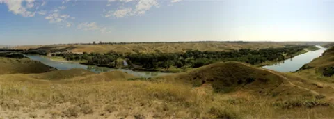
Panoramic view east from the promontory edge of the University Hall site to the Oldman River valley and city plateau.

Students

  • Academic calendar
  • Student Enrolment and Registrar Services
  • Student opportunities
  • Student services
  • Study here

Information for

  • Alumni
  • Donors
  • Visitors and community

Campus

  • Careers at uLethbridge
  • Events
  • Faculty and staff intranet
  • Maps and tours
  • News

Lethbridge Campus
4401 University Drive
Lethbridge, Alberta, T1K 3M4

Calgary Campus
Suite 6032, 345-6th Ave SE
Calgary, Alberta, T2G 4V1

Contact Us

Faculty & Staff Directory


Visit the University of Lethbridge Homepage

The University of Lethbridge is located on traditional Blackfoot Confederacy territory. We honour the Blackfoot people and their traditional ways of knowing in caring for this land, as well as all Indigenous peoples who have helped shape and continue to strengthen our University community.

Follow us on social media


©2025 University of Lethbridge | Terms of use