
Welcome to the University of Lethbridge
  • Library
  • Directory
  • Intranet
  • MyExperience
  • Webmail
  • Bridge
  • Moodle
Study here Give

Institute for Geospatial Inquiry, Instruction and Innovation

Welcome to the University of Lethbridge
Close
  • Core Team
  • Awards & Student Support
  • Past Events & Highlights
  • Library
  • Directory
  • Intranet
  • MyExperience
  • Webmail
  • Bridge
  • Moodle
Study here Give
Study here Give

Subsurface Sensing

See Beyond the Surface

i4Geo’s subsurface sensing capabilities support non-invasive investigation and mapping of features below the ground surface.

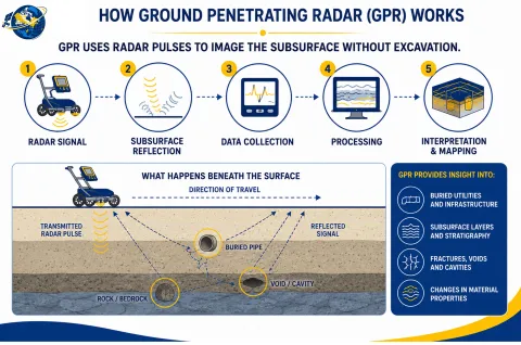
Using Ground Penetrating Radar (GPR), our team can collect and analyze subsurface information to support research and collaborative projects in areas such as environmental studies, infrastructure assessment, geological investigation, and subsurface mapping.

Ground Penetrating Radar (GPR) is a non-destructive geophysical technique that transmits electromagnetic signals into the ground and records reflections produced by changes in subsurface materials and buried objects. The resulting data can be used to investigate subsurface structures without excavation.

Discuss a Subsurface Sensing Project 

Sensors & Software SPIDAR® Multi-Channel GPR System

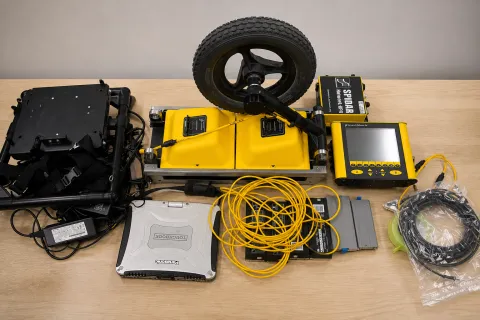
The Sensors & Software SPIDAR® system provides i4Geo with configurable, multi-channel Ground Penetrating Radar (GPR) capabilities for non-invasive subsurface investigation.

SPIDAR enables multiple GPR units to operate as an integrated system, allowing different radar configurations to be used according to project objectives and field conditions. The system can incorporate positioning information from an odometer and GPS to support spatially referenced subsurface data collection.
Image
GPR

Key Capabilities:

Multi-Channel GPR — Network multiple GPR units for coordinated subsurface data acquisition.

Flexible Survey Configuration — Configure the system for different survey objectives and subsurface investigation requirements.

Positioned Data Collection — Integrate odometer and GPS positioning with GPR measurements.

Large-Area Surveying — Collect multiple parallel lines of GPR data during a single pass.


Image
GPR_howitworks2

Institute for Geospatial Inquiry, Instruction and Innovation (i4Geo)

Professor Craig Coburn (Director)
  • WE2002
  • 4401 University Drive
    Lethbridge, AB, T1K 3M4
  • 403-317-2818
  • craig.coburn@uleth.ca

Students

  • Academic calendar
  • Student Enrolment and Registrar Services
  • Student opportunities
  • Student services
  • Study here

Information for

  • Alumni
  • Donors
  • Visitors and community

Campus

  • Careers at uLethbridge
  • Events
  • Faculty and staff intranet
  • Maps and tours
  • News

Lethbridge Campus
4401 University Drive
Lethbridge, Alberta, T1K 3M4

Calgary Campus
Suite 6032, 345-6th Ave SE
Calgary, Alberta, T2G 4V1

Contact Us

Faculty & Staff Directory


Visit the University of Lethbridge Homepage

The University of Lethbridge is located on traditional Blackfoot Confederacy territory. We honour the Blackfoot people and their traditional ways of knowing in caring for this land, as well as all Indigenous peoples who have helped shape and continue to strengthen our University community.

Follow us on social media


©2026 University of Lethbridge | Terms of use