Welcome to the University of Lethbridge
  • Library
  • Directory
  • Intranet
  • MyExperience
  • Webmail
  • Bridge
  • Moodle
Study here Give

Institute for Geospatial Inquiry, Instruction and Innovation

Welcome to the University of Lethbridge
Close
  • Core Team
  • Awards & Student Support
  • Past Events & Highlights
  • Library
  • Directory
  • Intranet
  • MyExperience
  • Webmail
  • Bridge
  • Moodle
Study here Give
Study here Give

Alberta Lake Monitoring Project


The Alberta Lake Monitoring Project uses satellite imagery and geospatial analysis to investigate long-term changes in Alberta’s lakes and surface-water systems. By integrating annual lake mapping, lake-level observations, LiDAR-derived elevation data, and dynamic geodatabases, the project aims to support improved monitoring of lake extent, connectivity, and hydrological change across the province.
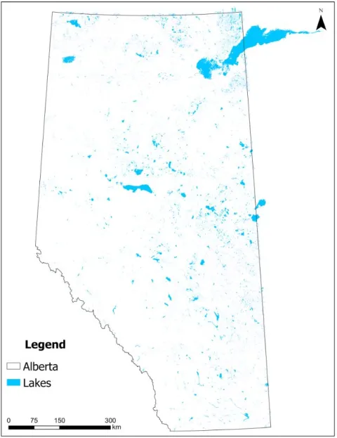
Project overview
This project uses multi-decadal satellite imagery and geospatial analysis to map annual lake extent across Alberta from 1984 onward. The goal is to support lake monitoring, water-resource planning, and future lake-volume estimation.

Image
ab_lakes01


What we are doing
We are creating annual lake polygon datasets, linking lake features through time, and building a dynamic geodatabase that allows users to track changes in lake area, fragmentation, and connectivity.


Why it matters
Alberta’s lakes are sensitive to climate variability, drought, land-use change, and hydrological shifts. Long-term spatial monitoring helps identify regional patterns of lake expansion, contraction, and changing water availability.


Data and methods
The project combines Landsat-based water products, high-resolution imagery, LiDAR-derived elevation data, lake-level records, and geodatabase tools to support validation and lake-volume modelling.

Image
utikuma


Image
ab_lakes03


Project outcomes
Expected outputs include annual lake extent layers, regional lake-area summaries, validation datasets, and a time-enabled geospatial database for monitoring lake change across Alberta.


Partners / collaborators
Alberta Environment and Protected Areas
Office of the Chief Scientist
University of Lethbridge
i4Geo

Institute for Geospatial Inquiry, Instruction and Innovation (i4Geo)

Professor Craig Coburn (Director)
  • WE2002
  • 4401 University Drive
    Lethbridge, AB, T1K 3M4
  • 403-317-2818
  • craig.coburn@uleth.ca

Students

  • Academic calendar
  • Student Enrolment and Registrar Services
  • Student opportunities
  • Student services
  • Study here

Information for

  • Alumni
  • Donors
  • Visitors and community

Campus

  • Careers at uLethbridge
  • Events
  • Faculty and staff intranet
  • Maps and tours
  • News

Lethbridge Campus
4401 University Drive
Lethbridge, Alberta, T1K 3M4

Calgary Campus
Suite 6032, 345-6th Ave SE
Calgary, Alberta, T2G 4V1

Contact Us

Faculty & Staff Directory


Visit the University of Lethbridge Homepage

The University of Lethbridge is located on traditional Blackfoot Confederacy territory. We honour the Blackfoot people and their traditional ways of knowing in caring for this land, as well as all Indigenous peoples who have helped shape and continue to strengthen our University community.

Follow us on social media


©2026 University of Lethbridge | Terms of use