Clayton Coulthard — Award Recipient
TECTERRA Geospatial Innovation Prize (2024 & 2025)
Clayton’s work focuses on applying remote sensing and GIS to better understand landscape processes and environmental change, with a strong interest in geomorphology and natural systems.
Highlights from Clayton's work included Modelling and 3D printing Terrain Maps, Mapping Inundation Zones for Beaver Dam Analogue permit applications with British Columbia Wildlife Federation, and Spectral Signature Collection of Invasive Species in the Lethbridge Riparian Zones of the Oldman River, partnered with the City of Lethbridge. More recently, Clayton has trained an Artificial Intelligence for detecting Beaver Dams and Lodges from Aerial Imagery.
────────────────────────────────────────
Featured Project: Beaver Browsing Bot (WDCAG 2026)

This project explores various model sizes and parameters to train a CNN framework that detects beaver dams and lodges across vast boreal landscapes, supporting targeted research and restoration planning.

────────────────────────────────────────
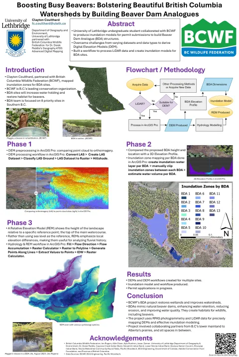
Poster 1 —Beaver Dam Analogue Inundation Modelling
Clayton Coulthard partnered with the British Columbia Wildlife Federation’s (BCWF) 10,000 Wetlands Project to process photogrammetric and Light Detection and Ranging (LiDAR) point cloud data. This work supported the creation of Digital Elevation Models (DEMs) and Relative Elevation Models (REMs) used to map Beaver Dam Analogue (BDA) inundation and assess hydrological impacts across wetland systems.
View Interactive Story Map →
────────────────────────────────────────
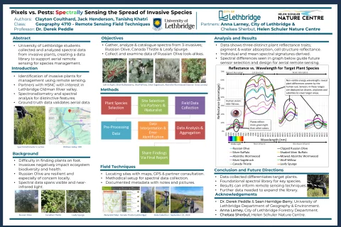
Poster 2 — Spectral Analysis of Invasive Species
This project investigates the use of field-based spectroradiometer data to characterize and differentiate invasive plant species, including Russian olive, Canada thistle, and leafy spurge. By analyzing spectral reflectance signatures across visible and near-infrared wavelengths, the study identifies distinct spectral traits related to pigment absorption, cell structure, and water content.
The results contribute to building a spectral library to support remote sensing applications, enabling improved detection and monitoring of invasive species using airborne and satellite imagery.
────────────────────────────────────────
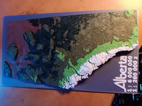
Alberta 3D Model
This project showcases a 3D-printed terrain model of Alberta derived from elevation data. By translating digital elevation models into physical form, the work provides an intuitive way to visualize topography, landscape structure, and spatial patterns across the province.