*****
Unfortunately,the trails of our early explorers are little known to us.
It was the writing of one of these explorers
that set me off on an amazing journey. In a library I stumbled across a
series of pages The Report on the Exploration
of the Kootenay and Boundary Passes of the Rocky Mountains in 1858  by Captain Blakiston, Royal Artillery. As I read his vivid description
of the landscape I thought how exciting it would be to retrace his route
to see just how accurate his descriptions are today.
by Captain Blakiston, Royal Artillery. As I read his vivid description
of the landscape I thought how exciting it would be to retrace his route
to see just how accurate his descriptions are today.
In 1978 with the help of a small grant from the Explorations Program
of the Canada Council, I began to research the route and get ready for the
joumey.
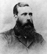
Blakiston, like many explorers, was an amazing man. Like his peers, whose
names he left on our landscape, he was a member of the British gentry. Such
men as David Livingstone, John Gould, Francis Galton and Charles Waterton
were some of the world's most respected natural scientists, and Blakiston
gave their names to Canadian landmarks.
When he was finished his explorations along
the rough southern Alberta and British Columbia border Blakiston continued
to distinguish himself. In 1861 he organized an expedition up the Yangtze
River in China and went 900 miles further than any westerner had before
him. During the 1870s he went into
business in Japan but his continuing interest
in nature led him to compile a catalogue
on birds
but his continuing interest
in nature led him to compile a catalogue
on birds  which for years was considered
the standard work on the birds of Japan. -
which for years was considered
the standard work on the birds of Japan. -
But it is his descriptions of the Canadian Rockies which are of interest
to us here.
It was on August 12,1858 that Captain Blakiston
started on his journey, roughly from a roadsign along the Calgary- Banff highway which describes the location of
Peigan or Old Bow Fort. His assignment was to explore the southern passes
of the Rockies to determine their possibilities for a railway.
along the Calgary- Banff highway which describes the location of
Peigan or Old Bow Fort. His assignment was to explore the southern passes
of the Rockies to determine their possibilities for a railway.
Following along the eastern edge of the Rockies, Blakiston travelled
not far from the modern Tumer Valley-Long- view road. To retrace his route,
continue south along highway 922 to the Maycroft campsite along the Old
Man River. Stay here a while for you are in the centre of an area rich in
history. But let us let Blakiston himself help us with our story.
"Before gaining Belly River in the morning, the quick and practised
eye of the Indian caught sight of a herd of buffalo in the valley; he therefore
went ahead, and by the time we had halted on the river, and I had obtained
an observation, he had killed one animal. I remained here until noon, in
order to obtain a meridian altitude, and so complete my observation for
latitude and longitude, occupying a portion of the time in measuring the
heights of the successive river levels with the aneroid barometer.
Take a few moments now and look at the river flowing by. Is it not just
as Blakiston described it well over a hundred years ago?
"The bed and sides of this river  are rocky, the strata
of hard grey sandstone, much inclined, and the current obstructed in places
by immense granite boulders. We found no difficulty in crossing, the water,
though running swiftly, being not deeper than three feet, and about 25 yards
across. "
are rocky, the strata
of hard grey sandstone, much inclined, and the current obstructed in places
by immense granite boulders. We found no difficulty in crossing, the water,
though running swiftly, being not deeper than three feet, and about 25 yards
across. "
Drive a short distance west following the Old Man River to where it flows
from the mountains.
"Looking through the gap in the near
range through which the river issues, I saw a very decided dome-shaped mountain
. . . after the distinguished British naturalist, I named it 'Gould 's Dome' "
As you proceed south down highway 922 go slowly and look carefully; ahead
you will see exactly what Blakiston describes .
"Looking to the mountains ahead of
us I picked out the most prominent, and took bearings of them . . . There
were two near one another bearing 30 miles south, one of which, from the
resemblance to a castle on its summit, I named 'Castle
Mountain;'  to the east of these, but at
a greater distance, a portion of the mountains stretched out to the eastward
From reports which I had previously heard, I took the most easterly one,
standing by itself, to be the 'Chief's
Mountain,'
to the east of these, but at
a greater distance, a portion of the mountains stretched out to the eastward
From reports which I had previously heard, I took the most easterly one,
standing by itself, to be the 'Chief's
Mountain,'  which the Indian on coming up
confrmed, and pointed out the place where on the morrow we should turn into
the mountains.
which the Indian on coming up
confrmed, and pointed out the place where on the morrow we should turn into
the mountains.
It was on August 20,1858, a day thick with
haze and occasional rain that Blakiston "crossed Crowsnest
River  and after noon gained the entrance of
the Kootanie pass, where another of the branches of Belly River issues from
the mountains. Here we struck a narrow but tolerably well-beaten track,
which the Indian informed us was the Kootanie trail, by which these Indians
had crossed the mountains the past spring.
and after noon gained the entrance of
the Kootanie pass, where another of the branches of Belly River issues from
the mountains. Here we struck a narrow but tolerably well-beaten track,
which the Indian informed us was the Kootanie trail, by which these Indians
had crossed the mountains the past spring.
Our modern day explorer should proceed west on Highway 3 to Hillcrest.
At this point go south and if you continue on to the Lynx Creek campground,
the chances are good that you will be very close to where Blakiston camped.
"The travelling was good, for we
were on the even grassy river levels, and we camped at a spot where a small
mountain stream entered the river from the north.
The Kootenay trail followed up what we today call the Carbondale. This
in turn flows into the Castle, or what Blakiston described as the Railway
River.
From Lynx Creek
 Campground until the mid 70s a four-wheel drive
trail would have taken you up and over into the Flathead. But today, by
the time you reach Blakiston's "Hero's Cliff' -- about one and a half
miles from the summit -- you will find the rest of the trail bulldozed into
oblivion, and you must start to hike.
Campground until the mid 70s a four-wheel drive
trail would have taken you up and over into the Flathead. But today, by
the time you reach Blakiston's "Hero's Cliff' -- about one and a half
miles from the summit -- you will find the rest of the trail bulldozed into
oblivion, and you must start to hike.
"Here we passed Hero's
Cliff, an enormous vertical escarpment, facing the
east, of hard red sandstone or quartzite, with the strata dipping at least
45 degrees to the west.
an enormous vertical escarpment, facing the
east, of hard red sandstone or quartzite, with the strata dipping at least
45 degrees to the west.
Over the last few years the eastern slopes of the Rockies have been scarred
with ruts from four-wheel drives. The decision was wisely made that most
of these should be destroyed and the land left for nature to reclaim. Eventually though, I foresee the time when these
historic passes through the
Rockies will be reopened as heritage hiking trails. The pass will be perfect
for that. Therefore as you trudge slowly along, take heart in the fact that
you too are a pioneer-- just ahead of your time.
through the
Rockies will be reopened as heritage hiking trails. The pass will be perfect
for that. Therefore as you trudge slowly along, take heart in the fact that
you too are a pioneer-- just ahead of your time.
Again you will feel the excitement as vou
observe the identical picture Blakiston described well over a century ago:
"Gradually the stream became less and less until after gaining considerable
altitude it dwindled into a small quatity of water falling in a cascade.
We now rose rapidly, the trees became smaller, and we soon reached the region
of rock and alpine plants; here were some large patches of snow and a couple
of ponds of clear water; we passed over a quantity of debris of hard gray
limestone, of which the peaks on our
right hand, namely N.W., were composed. As we were now clear of all shelter,
we felt the cold damp east wind.
on our
right hand, namely N.W., were composed. As we were now clear of all shelter,
we felt the cold damp east wind.
Here at the
top , sit back in time and contemplate the thoughts
Blakiston had at this same spot.
, sit back in time and contemplate the thoughts
Blakiston had at this same spot.
"We are now on the watershed of the mountains, the
great axis of America ; a few steps farther
and l gave a loud shout as I caught the first
glimpse
; a few steps farther
and l gave a loud shout as I caught the first
glimpse in a deep valley, as it were at my
feet, of a feeder of the Pacifc Ocean. It was the Flathead River, a tributary
of the Columbia. At the same moment the shots of my men's guns echoing among
the rocks announced the passage of the first white man over the Kootanie
Pass.
in a deep valley, as it were at my
feet, of a feeder of the Pacifc Ocean. It was the Flathead River, a tributary
of the Columbia. At the same moment the shots of my men's guns echoing among
the rocks announced the passage of the first white man over the Kootanie
Pass.
Other white men had probably crossed the
pass before Blakiston, but he was the first one to record his crossing and
the fact that he did it so vividly is our good fortune.
"A rapid descent of two hours brought us to the Flathead
River, a clear and quick running stream, dividing a beautiful partially
wooded valley enclosed by mountains; here we halted soon after mid-day,
having passed the great watershed, and descended again 1,400 feet without
breakfast.
More In the Footsteps
of Thomas Blakiston
How do
I participate in the student Sketchbook Project?
Thomas Blakiston in Japan
 Back to Our Heritage
Home Page
Back to Our Heritage
Home Page