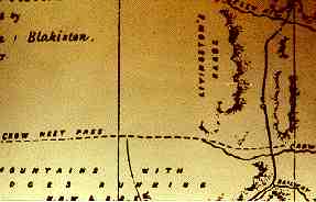
This historic map from the Palliser Expedition shows Blakiston's route
crossing the Belly River![]() (now Old
Man River), then following the valley between the Livingstone
Range
(now Old
Man River), then following the valley between the Livingstone
Range![]() and the Porcupine Hills.
and the Porcupine Hills.
He notes a trail coming from the Crows Nest Pass but decides not to follow it, instead, taking the route preferred by the Natives - the North Kootenay Pass.
Note: On the map he has named today's Castle River "Railway River."
Return to In the Footsteps of Thomas Blakiston
How do
I participate in the student Sketchbook Project?
Thomas Blakiston in Japan
![]() Back to Our Heritage
Home Page
Back to Our Heritage
Home Page