|
Monday, December 31, 1792 -
Describes Chief Mountain 
At 7 AM we resumed our Journey, went SSW 6 miles & set a high cliff on the Eastern edge of the Rocky Mountain, S43 dgrees E, about 25 miles off, called by these Indians Nin nase tok que or the King & by the Southern Indians the Governor of the Mountain, being the highest known place they know off, it Inclines to the East, having a lean that way towards the top its elevation above the level of its base I suppose is not less than 4000 feet. This I estimate, with the comparison of a place that I afterwards measured, which does not appear near so high as the King.
Arrival at the Old Man River 
Then went SWbS 3 miles & came to the New pew ooch ke tay cots river about 20 yards wide, good current & pretty deep, betwixt the rapids which are pretty frequent, with steep rocky sides in places, Went up along the river on the north side W 1 1/4 mile & arrived close at the Eastern edge of the Mountain.
Here the Cottonahew chief met us alone & saluted us in his manner all with a kiss. We then crossed over the river to the South side, as it was not possible any farther on the North on account of the high hills & woods. When we crossed over the river, which was not froze over, we found 12 Cottonahew Men sitting on the Ground where we arrived at 11 AM.
All our Indians & the Cottonahews formed themselves into a circle and sat down & smoaked together 3/4 of an hour, when we set off  all together to their Tents which was upon the Bank of this river a little way within the Mountain. all together to their Tents which was upon the Bank of this river a little way within the Mountain.
At the side of the river at the entrance into the Mountain very high, steep perpendicular rocks.  Went along the South side of the river within the Mountain WSW1/2 mile & took Sextant reading. Then continued our way close along the bank of the river which is very rocky but a narrow bare pass Betwixt the water & the high perpendicular rocks of the Mountain, S 1/3 of a Mile. Went along the South side of the river within the Mountain WSW1/2 mile & took Sextant reading. Then continued our way close along the bank of the river which is very rocky but a narrow bare pass Betwixt the water & the high perpendicular rocks of the Mountain, S 1/3 of a Mile.
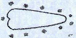
 Old Man's Playing Field Old Man's Playing Field
A place here called Naw peu ooch eta cots from whence this river Derives its name.
It is a place where Indians formerly assembled here to play at a particular Game with by rolling a small hoop of 4 Inches diameter & darting an Arrow out of the hand after it & those that put the arrow within the hoop while rolling along is reckoned to have gamed.
This is on a fine level grass plain, very little bigger than the enclosed space. One side is within 10 yards of the river & the direction of this curiosity is directly one North & South. All those pieces that compose the outer & inner parts are small stones set close together about the bigness of a persons fist above the ground, & they are so close set & neatly put together that it appears one entire ledge of stones.
There are 11 piles of stones, loosly piled up at regular distances along the out sides, about 14 Inches in Diameter & about the same height. These I imagine to have been places for the Older men to sit upon to see fair play on both side & to be the umpires of the Game. Here follows a sketch of the place:
On my enquiring concerning the origin of this spot, the Indians gave me a surprising & ridiculous account. They said that a White man (what they universally call Europeans) came from the South many ages ago, & built this for the Indians to Play at, that is different nations whom he wished to meet here annually & bury all anamosities betwixt the different Tribes, by assembling here & playing together. They also say that this same person made Buffalo, on purpose for the Indians. They describe him as a very old white headed man & several more things very ridiculous.
Then go along the river as before, W1/2 mile, and arrive at 7 Cotton ahew Tents, which are of a smaller size than our Indian’s Tents but made & pitched in the same manner.
The Indians began to barter for horses as soon as we arrived & soon bought all the Cottonahews had to show, for a mere trifle, some only giving an old Hatchet, some an old Kettle, &c. &c. Several of our Indians returned Back in the Evening to their own Tents & the remainder stays here until tomorrow.
Fidler Goes Exploring
After smoaking a Pipe with the Cottonahews, I went away privately up the river to examine & measure the altitude of the Mountain in this place. Had the Indians have known they would some of them have accompanied me & hindered me from making the remarks I wished.
Went up the river West 1/4 mile above the Tents, when this river divides into 2 branches, one running from the NNW 2 miles up that reach in sight, & the Southern branch SwbW 1 1/4 mile. (Racehorse Creek) Where the rivers part pretty large pine & poplars & 2 new Beaver houses, also on the South side a large spring of excellent water spouts up from under the perpendicular rocks.
That water in these rivers is very clear & appears at times to rise above 18 feet perpendicular as I could find by small pieces of driftwood lying upon the branches of Pine trees that height above the level of the river. This South West branch of the river is the one the Cottenahew Indians come along from the West side of the Mountain, the Head of which by their account is about 2 of their days journey in these difficult parts which is about 14 miles from the Western edge of the Mountain.
There is no way of passing over these Mountains in these Latitudes, except along rivers & here it is attended with great hardships & danger. These Indians slept 5 nights from the Western to this place which as I could find from the Indians is about 40 miles a SWbS Course. They say that it is nearly of an equal breadth from the report of different Indians who have crossed over it in different places.
Describes Mountain Formations
I climbed up a gentle ascent, this making an angle of more than 60 degrees with the horizon, and after much fatigue I got to the top (probably Thunder Mountain) in 2 1/2 hours time, from which an extensive view may be seen into the Country to the Eastward, but to the Westward the high Mountain hides the eye from seeing to any considerable distance all in that direction.
There was only a few places with in the eyes extent that is higher than the place I stood on. Here the Mountain stands upon a level base, but to the N West toward the Head of the Bad river & the Devils Head, the mountain is upon an uneven foundation, the eastern parts dip & the Western rising gradually above one another in the interior of the Mountain.
**** (Part included in journal but not here.)
On the top of the Mountain I found a deal of sheep Dung but saw none of these Animals, altho’ they are very plentiful all thro the Mountain, & never leave it to visit the Plains more than a mile or 2 from the Mountain. There are also Goats here, of a small black sharp pointed horn like a young bull calf. There are also several other animals here in the Mountain that the Indians describe, but from their description from want of knowing a sufficiency of their language, I was unable to judge what sort of animal they mean.
**** (Part included in journal but not here.)
Tells what he knows West of Rockies
**** (Part included in journal but not here.)
A Kootenay Indian Kitchen
...
Slept in the Cott ahew tents where I returned after my ramble at dusk in the evening.
Piegans Not Happy with Fidler’s Exploration
Our Indians had missed me soon after I went away, & they sought me everywhere they thought to have found me, never thinking I would undertake the great trouble and fatigue of ascending to the summit of the Mountain. They even suspected that the Cottonahews had some of them killed me slyly & had I had any accident, they would have fallen on the innocent Cottanahews & killed them all.
Fidler Trades with Kootenays
I traded from these Indians 2 Drest Sheep Skins, very light & supple, 1 Wolf Skin, ill dressed & 2 Beaver Skins, which was in the same predicament, part of the flesh still adhereing to the Skin. The Hair of the Beaver was short & of a dirty brown colour.
Pipe Etiquette
After being in the Tent some little time, the Chief Man filled a pipe & smoked to me & several Muddy river Indians, after lighting the Pipe he made a speech in his own tongue which I did not comprehend one word. He then made several signs with his pipe stem, when he took 4 good hearty wiffs & gave it to me.
I was according to the customs I had seen amongst other Indians smoaking away at my ease, but after the 4th wiff he took the Pipe from me & made me understand by signs that 4 was the number upon extraordinary occasions, making Peace, meeting friends & strangers, as was the case at present.
When the Pipe was out he filled another, all of his Tobacco of their own Growing, & gave to me & made me understand that I should light it & make the same ceremonies with the pipe as we did in our own country, but I made several curious motions with it that they could not comprehend or myself either, however as I kept my gravity, tho’ with great difficulty during the ceremony, & then took 3 hearty whiffs, & delivered it to the next in rotation, when every one gave a great ho, three times, & these people appeared to be highly pleased at my dexterity with the Pipe.
Separate Quarters
These people (Chiefs) have a Tent for each wife, whom they visit occasionally. The reason they assign for this singular custom is that too many wives together never agree, which is good reasoning, This Man had 4. He was about 40 years of age, and of a smaller stature. I was the first European they had ever seen.
Middlemen
They never was near any of the Trading Settlements, altho they much wish it. But the Muddy river, Blood, Black Feet & Southern Indians always prevent them, they wishing to monopolize all their Skins to themselves, which they do, giving the Poor Indians only a mere trifle for. They scarce give them as much for 10 Skins as they can get for one at the Trading Settlement.
**** (Part included in journal but not here.) |
|
|
|
|