Background Information on James Hector
Other Historic Journals by Explorers of the West
We encamped beside this stream, ...
I then ascended the mountain to the east for 1000 feet
above our camp, reaching the limit of the woods after 500 feet.
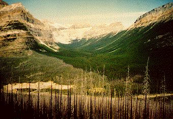
One morning I climbed up the same slope. Looking at Hector's map the
centre mountain would appear to be the one he named Mount Lefroy. Today's,
Mount Lefroy is located further north.
Check this for yourself. Here you will find Hector's
map alongside a modern map
In any case, John Henry Lefroy, R.A. (1817 - 1890) was a noted astronomer
who measured the magnetic declination at a number of points in Canada as
well as the Cape of Good Hope and St. Helena. He was head of the Toronto
Observatory from 1842 - 1853 and in later years was governor of the Bermudas
and Tasmania
How do I participate
in the student Sketchbook Project?
Background Information on James Hector
Other Historic Journals by Explorers
of the West
![]() Back to Our Heritage Home Page
Back to Our Heritage Home Page