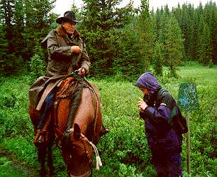
Atop Elk Pass my daughter Charlotte checks the altimeter for Larry Boyd. Years of sun filled days riding the trail have weaked his eyes.
Palliser recorded on the 22nd of August we reached the height of land between the waters of Kananaskis River and a new river, a tributary of the Kootenay River. We remained here for the rest of the day, occupied with observations. Our height above the Bow Fort was now 1885 feet, above the sea 5985 feet.
Our reading was just over 6000 feet. Compare that with the North Kananaskis Pass which is about 7800 feet.
John Palliser's Exploration of the Canadian Rockies
Back to Following Historic Trails Index