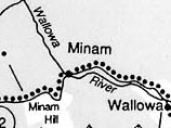
The Treaty of 1855 set the limits of the Nez Perce land with the western most edge running north-south along Minam Hill that forms the divide between the Grande Ronde and the WalIowa River drainages.
In order to have all people understand how much land we owned, my father planted poles around it and said: Inside is the home of my people-the white man may take the land outside. Inside this boundary all our people were born. It circles around the graves of our fathers, and we will never give up these graves to any man.
Chief Joseph
The boundary referred to by Chief Joseph consisted of about seven posts located on the hill somewhere south of where Oregon 82 crosses Minam Hill today. Poles set in stone cairns marked the western edge of Nez Perce land because Chief Old Joseph realized that settlers would enter his country from the west — as travellers do today.
The Nez Perce Flight to Canada - An Introduction