some places, whole prairie covered with its brownish grey wooly heads. Ge-um Triflorum becoming less common going West. Astragalus caryocarpus [Ground Plum] becoming more common since leaving Pembina R. & now to be seen almost everywhere. Gnaphalium or Cudweed? [Yes] & Lithospermum canescens [Hoary Puccoon] just coming out
[EDITORS NOTE: The balance of May 31, if any, and all of June 1 are missing from the microfilm of the diary.]
June 2. Left camp at 6 o'c & travelled over gently undulating prairie of fine appearance to Souris River. The soil appears good throughout. Many little ponds & swamps.
Passed a party of Sioux travelling from Turtle Mt to the Souris. Their goods packed on the back of a small pony & on a travaille [travois] behind. Several dogs with similar triangular drags also carried a part of the stuff.
Caught up with the ox train shortly after lunch & on arriving at the Souris found all the parties just camped.
The river is so high as to be unfordable. Found on sounding 7'3", in middle & stream 150 ft across. Preparations to build a bridge commenced. Rowe & Burgess attempt twice to take a rope across by means of two box water [?] carts lashed together, but did not succeed. Rowe finally swam over with a rope.
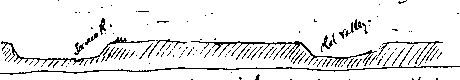
The long & wide valley passed over about 2 miles west [?] of here is evidently an old alternative valley of this stream. (See notes of last year). Took distance by odometer & elevation by Barometer to ascertain how much the R. had cut down since leaving the old valley & to obtain data for making a section across.
Bar. on prairie level E. side of old valley 28.13. A gradual slope for about 200 yds. Odom. at E. lip of valley 10175. Bar at lowest part of valley 28.21. Odom at W. lip 10545. Bar=28.15. Bar at summit between old valley & Souris valley=28.14. Odom at edge Souris valley 11435. Bar at water level. Souris River. 28.23.